Seeking solid scientific ground for engineering soil sustainability

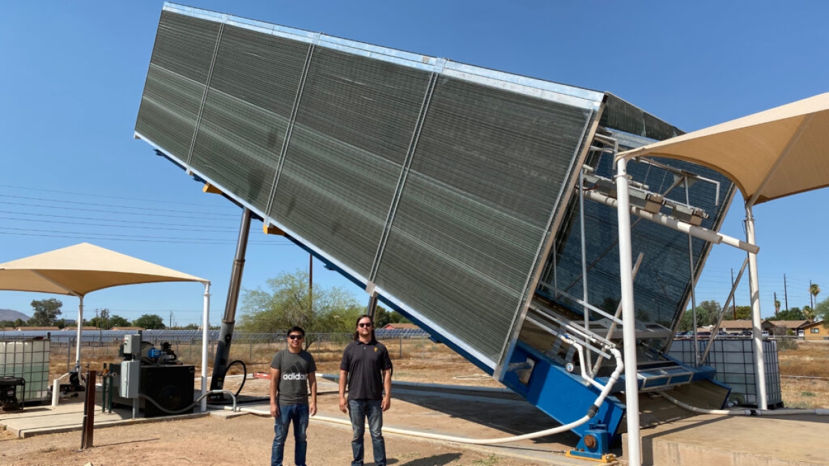
Robin Cheng (left) and Eric Escoto are pictured with a large landfill tipper at a field laboratory on Arizona State University’s Polytechnic campus. The tipper is an essential part of the facility designed for soil erosion research. Led by Escoto, a geological sciences doctoral student, the project aims to develop more effective ways to observe, prevent and reduce soil erosion that is creating environmental hazards in many places around the world. Photo courtesy of Kimberly Martin/Center for Bio-mediated and Bio-inspired Geotechnics
Soil erosion is a growing worldwide challenge. Its spread threatens dire consequences for the health of fragile environments and the stability of natural resources, agriculture, civil infrastructure and other essential foundations of society.
That’s why engineers and scientists are employing advanced technologies — sensing systems, laser-based ground surface change detection and monitoring devices, and highly precise measurement tools — to better observe, prevent or reduce soil erosion. In some cases, they even induce it for experimental purposes.
Those mechanisms have been incorporated into an installation called the large outdoor rainfall and infiltration simulator, or LORIS, at the Center for Bio-mediated and Bio-inspired Geotechnics Soils Field Laboratory on Arizona State University’s Polytechnic campus. The structure is the defining project in Eric Escoto’s research as a geological sciences doctoral student in ASU’s School of Earth and Space Exploration.
Through the facility’s capabilities, Escoto hopes to contribute to the development of more effective methods of large-scale erosion control and reduction of soil loss.
Escoto has spent nearly three years designing and building LORIS to exceed the compliance standards set by the American Society of Testing and Materials, known as ASTM.
“Exceeding the compliance standards will make it easier for us to develop industry partnerships for more extensive erosion control research and erosion control products testing,” Escoto said.
Bolstering resilience to the erosive impacts of wildfires, earthquakes, flooding and other extreme events — as well as human actions that alter ecosystems — is critical to the sustainability of communities’ water, power, transportation, waste control and public safety systems.
Escoto aspires to take steps toward solutions that protect against such perils. He foresees finding answers in the voluminous trove of data to be amassed through his project’s penetrating probes into the intricate interactions of rain and soil.
Monsoon provides perfect setting for geotechnical testing
The work is part of the Center for Bio-mediated and Bio-inspired Geotechnics' mission as a National Science Foundation, or NSF, Engineering Research Center at ASU. The center is directed by Edward Kavazanjian, an ASU Regents Professor and the Ira A. Fulton Professor of Geotechnical Engineering in ASU’s Ira A. Fulton Schools of Engineering.
Escoto’s adviser is Enrique R. Vivoni, a professor on the faculties of both the School of Earth and Space Exploration and the School of Sustainable Engineering and the Built Environment, one of the six Fulton Schools, in which Kavazanjian also teaches.
The simulator is designed to direct rainfall in specific amounts to a soil test bed. Runoff from the test bed will then be measured by sensors to determine the amount of water, the loss of sediment induced by erosion and the infiltration and storage of water in the soil.
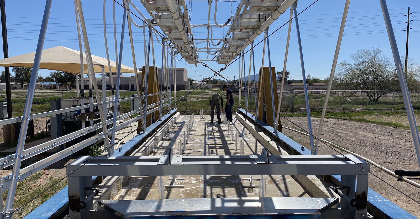
Zachary Keller (left), a geological sciences graduate student, and Robin Cheng are shown positioning the rain gauges for a calibration test on the large outdoor rainfall and infiltration simulator. The system features nozzles designed to shower a soil bed with water that simulates the size and distribution of natural raindrops. Others who have helped with the design, construction and operation of the research facility include ASU mechanical engineering graduate Anant Gogate, civil engineering graduate Brandon Bohan and current civil engineering undergraduate Leslie Bautista. Photo courtesy of Eric Escoto
“Our region is an important factor in the design and use of the rainfall simulator,” Vivoni said. “The Sonoran Desert region in Arizona has two rainy seasons, winter and the summer monsoon season, which have their own distinct types of rainfall.”
Dry conditions and high winds characteristic of the regional climate affect the runoff measurements in several ways, including how the raindrops travel through the simulation apparatus and how the soil test bed dries between experiments, Vivoni says.
A significant feature of the rainfall simulator is the “landfill tipper” used to elevate the soil test bed, Kavazanjian says. Tippers are commonly used to empty municipal solid waste transfer trailers at landfills. They can tilt the trailers by an angle of up to 45 degrees so the waste material falls completely out of the trailer and onto landfill surfaces.
The LORIS facility’s hydraulic tipper can tilt a 40-foot-long, 8-foot-wide, 25-ton bed of soil.
Synthetic rainfall is then induced by an overhead sprinkler system equipped with nozzles designed to shower the soil bed with water in a way that simulates the natural size and distribution of raindrops.

Digging deeper into the complex interplay of water and soil
Escoto’s project furthers the work of the Center for Bio-mediated and Bio-inspired Geotechnics' on biogeotechnical treatments to enhance the properties of soil. His initial experiments will focus on the effectiveness of a process developed for wind erosion control for controlling erosion due to surface water runoff. He will explore possibilities for enhancing that process.
The ability to measure surface water infiltration, subsurface soil water storage and surface water runoff enables the facility to do much more than evaluate the effectiveness of erosion control technologies and methods.
“We can do fundamental research on what is referred to as water balance, which is how the total precipitation is divided between runoff, storage in the soil and percolation through the soil on a sloping surface,” Kavazanjian said.
“Using water balance analyses, we can also investigate the impact of various erosion treatments and the associated infiltration of surface water on slope stability and the effectiveness of soil covers for landfills and hazardous waste containment systems, and address a number of equally important geohydrological challenges,” he said.
LORIS is one of only four facilities of its kind in the United States, Kavazanjian points out. The others are a U.S. Department of Agriculture facility at Purdue University, a commercial facility in South Carolina and another research installation at Texas A&M University.
Vivoni notes that ASU’s facility includes a terrestrial scanning light detection and ranging device, known as lidar, to measure the erosion of surface soil through the use of a focused laser beam to reveal changes in soil elevation after erosion treatment tests.
In addition, the facility includes an outdoor weather station and an optical disdrometer, a laser-based precipitation sensor that samples the size and speed of individual synthetic rainfall droplets.
With the combination of those technologies, Escoto expects the facility to yield data to help produce synthetic rainfall that mimics the physical characteristics of natural rainfall.
He will compile additional data to guide him in enabling the simulator to adjust the drop size, velocity, evaporation and impact force of both natural and synthetic rainfall to varying meteorological conditions and other environmental factors.
Education outreach and expanded research plans
“I also want to make use of the experimental facility as an educational tool open to all,” said Escoto, whose doctoral studies are supported by an NSF Graduate Research Fellowship and the ASU Graduate College Interdisciplinary Enrichment Fellowship. The NSF fellowships are awarded to graduate students who show potential to be education and research leaders in their fields.
“The project is geared to being accessible to the public for opportunities to learn about rainfall-induced erosion on hillslopes and regional flood hazards through hands-on demonstrations of rainfall and erosion processes,’’ Escoto said.
He also wants to see the simulator facility be adapted for use in other areas of engineering and science — in particular research aimed at making advances in weather and hydrology research.
More Science and technology

4 ASU researchers named senior members of the National Academy of Inventors
The National Academy of Inventors recently named four Arizona State University researchers as senior members to the prestigious…

Transforming Arizona’s highways for a smoother drive
Imagine you’re driving down a smooth stretch of road. Your tires have firm traction. There are no potholes you need to swerve to…

The Sun Devil who revolutionized kitty litter
If you have a cat, there’s a good chance you’re benefiting from the work of an Arizona State University alumna. In honor of…


