Forest thinning may provide water benefits downstream

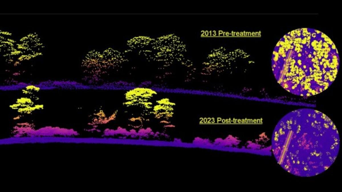
ASU and SRP are investigating whether forest thinning will increase water supplies downstream, with researchers using a new modeling technique to estimate the water benefits. This image shows a cross-sectional LiDAR point cloud comparison of a treated forest at a research site in the Coconino National Forest. Courtesy image
Arizona’s wildfire season has begun, as several fires are burning across the state. Long-term drought and climate change contribute to the intensity of these fires, which are often human caused.
Following a wildfire in the state’s watersheds, rainfall washes ash and debris into rivers, the reservoirs that provide water to the Valley. When a large amount of debris fills the reservoirs, it reduces the capacity for water storage and can damage water infrastructure such as dams and water treatment plants.
In a pilot program, Arizona State University and Salt River Project are investigating whether forest thinning will increase water supplies, in addition to reducing wildfire risk and protecting important infrastructure. The project is focused on a 3,400-acre area in the Kaibab National Forest.
The research team developed a cutting-edge modeling technique for estimating water benefits derived from forest thinning and restoration. Specifically, they created a high-resolution map of the watershed — one that accounts for trees along with their height, size and species using light detection and ranging, or LiDAR, surveys and high-resolution imagery of the land. The LiDAR, combined with other image data, generated a precise, three-dimensional surface of the watershed.
Above: 3D LiDAR point cloud comparison of a treated forest within the Baker Thinning Project in the Coconino National Forest.
Professor Enrique Vivoni, director of the Center for Hydrologic Innovations at ASU, along with graduate students and postdoctoral scholars from the center, combined the LiDAR results with other publicly available datasets to create a new model of a thinning project area.
“Arizona is at a crossroads in terms of our water supply portfolio. Applied innovation projects, such as this effort in forest health and water resilience, translate research into actions for the benefit of our renewable water supplies. Not only does our work with SRP set the stage for regional impacts, but it is also a successful model for how universities can collaborate effectively with water agencies and utilities,” Vivoni said.
The pilot program determined that forest thinning on approximately five square miles of land in the Kaibab National Forest would generate approximately 230 acre-feet, or nearly 75 million gallons of water during the first year. One acre-foot of water can provide water for three Arizona families for one year.
This research, conducted by the Center for Hydrologic Innovations, is part of the Arizona Water Innovation Initiative — a statewide project led by the Julie Ann Wrigley Global Futures Laboratory in collaboration with the Ira A. Fulton Schools of Engineering.
“The SRP–ASU innovative water model is applying research to real-world projects to help us understand the watershed benefits of forest thinning. This collaboration has proven to be invaluable as we continue to find ways to ensure water reliability during a record drought and shortages of other sources of water such as the Colorado River,” said Elvy Barton, SRP manager of water and forest sustainability.
SRP manages the water supply for much of the Valley — most of which comes from more than eight million acres of land in northern Arizona. Snowfall and rain provide the water that travels through the watershed into its reservoirs, which is then delivered to 2.5 million homes and businesses in the Phoenix Metropolitan area.
In addition to the pilot study, ASU and SRP are modeling forest thinning projects in the East Verde River and East Clear Creek watersheds, which provide water to Payson and are areas at high risk for catastrophic wildfire. Results from that investigation in the Coconino National Forest are expected later this year.
More Environment and sustainability

The mighty impact of insects
By Meghan Finnerty and Megan NeelyArizona State University has a lot of insects — and for good reason. A colony of researchers is studying how social insects can be used as tools to answer…

Majority of American religious leaders silently believe in climate change, ASU study shows
Many Americans turn to religious leaders for guidance on matters of faith and morality.With this in mind, a new study, led by a researcher from Arizona State University, suggests that congregations…

A new university prototype for a thriving world
The challenges for our world’s health and the future of humanity and other life-forms command urgency — and the university is accelerating its wide-reaching collaborative work to help keep the planet…

