New web tool maps regional heat vulnerability, health data

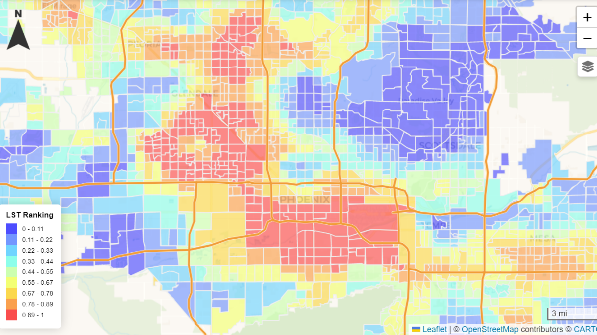
The customizable map shows variances in heat across the region. Photo courtesy the Julie Ann Wrigley Global Futures Laboratory
Under the intensity of the Arizona summer sun, a young pair of siblings press together in an attempt to share shade under an umbrella as they walk home from school. Elsewhere, a woman experiencing homelessness takes refuge from the scorching sidewalks in the shaded parking structure of a local business complex.
Clearly, avoiding the heat in the Valley of the Sun becomes a necessity as temperatures rise.
To measure heat vulnerability and health data, a group of students and faculty from Arizona State University's Julie Ann Wrigley Global Futures Laboratory created a new tool, the Cool Region Webtool. In addition to mapping heat vulnerability data, it provides insights into potential solution strategies.
One of the purposes of the web tool is to provide heat vulnerability information to urban planners and other decision-making community members. Katja Brundiers, a clinical associate professor in the School of Sustainability and one of the co-creators of the tool, said that putting heat considerations at the forefront of planning goes beyond being courteous — it can save lives.
“Heat is a silent killer,” Brundiers said, “but it doesn’t generate a lot of public awareness because it is a silent killer. And yet, we lose almost 600 people related to heat every year.”
The web tool features vulnerability variables such as temperature, socioeconomic status, household composition and disability. It also includes minority status and language in addition to housing type and transportation. These variables can be adjusted with a sliding scale to create a highly customizable searching experience.
“We can use this data and start thinking about health outcomes in a more positive sense from the beginning, and not at the end of a project,” Brundiers said. “Instead of planting a tree here or there at a completed project site, you can think about how to situate a whole building to create shade throughout the structure.”
Paul Coseo, who co-led efforts to create the web tool, is a program head and associate professor of landscape architecture, urban design and environmental design at The Design School. Coseo said the Cool Region Webtool builds off of work from a previous project between the city of Tempe and ASU heat researchers, funded through ASU’s Healthy Urban Environments Initiative.
“We initially collaborated on a heat map of just Tempe, but heat is a regional phenomenon because people often live, work and play in different places,” said Coseo, who is also a senior global futures scientist. “Through this consecutive Healthy Urban Environments grant, we were able to come together a second time and work with university and community partners to expand a city-focused heat map project into what it is now: a regional heat vulnerability map.”
ASU partners include the Decision Theater, a group of data scientists, software engineers, technical experts and graphic designers who actually integrated the data and built the user interface.
In line with Decision Theater’s mission statement, to explore solutions to complex societal issues, the new Cooling Region Webtool includes a tab dedicated to solutions. Potential considerations mentioned in the solutions tab include selecting the right trees to optimize shade, shading playgrounds to lower surface temperatures and increasing heat awareness in manufactured or RV homes.
Azza Dhahri, a graduate student in urban design at the Herberger Institute for Design and the Arts, said working on the web tool was an opportunity to explore the relationships between community resilience and the built environment.
“Cooling strategies can mitigate climate hazards related to heat, but it also has components of improving day-to-day life by creating, for instance, shade structures that also offer recreational activities and opportunities for social connections,” Dhahri said. “Urban design, when done strategically and mindfully, can bring a community together.”
The tool also has the potential to support “equitable cooling” practices. Brundiers describes equitable cooling as investing in cooling infrastructures in areas that experience the highest heat exposure, which often overlap with other socioeconomic and racial variables. In shorter terms: Heat is a concern that often hits vulnerable populations first, and worst.
On a map of the Valley, the web tool’s data groupings are broken into small sections. This allows users of all backgrounds to compare data from their own neighborhood to other locations across the Valley.
“People have the ability to look at their areas and relate it to their own lived experiences,” Brundiers said. “They can then come together at places such as neighborhood associations or city government meetings — or even at a regional level — and they can create an understanding on where and why those lived experiences are different. Most importantly, they can use this information as they apply for federal grants that fund infrastructure investments that cool our region and address heat inequities.”
More Health and medicine

College of Health Solutions alumnus named Military Medic of the Year
By Keri Hensley and Kimberly LinnJonathan Lu has looked out for the health of his fellow military service members his whole…

ASU, Mayo Clinic forge new health innovation program
Arizona State University is on a mission to drive innovations that will help people lead healthier lives and empower health care…

Innovative, fast-moving ventures emerge from Mayo Clinic and ASU summer residency program
By Georgann YaraIn a batting cage transformed into a custom pitching lab, tricked out with the latest in sports technology,…