New study reveals tourists love Hawaiian coral reefs just a little too much
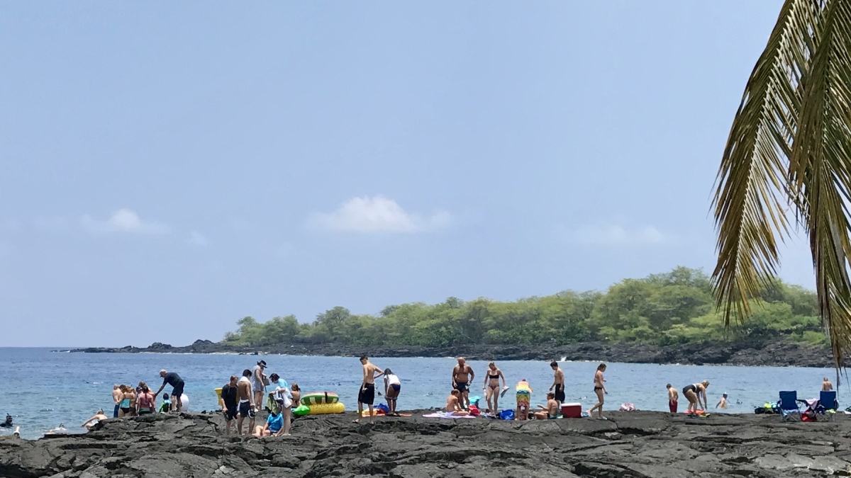
Hawaiian coral reefs are popular tourist sites. This is cause for concern, as highly visited coral reefs are negatively impacted by elevated pollution, infrastructure and development, as well as on-reef visitation and the physical damages accrued through recreating tourists. Photo by Greg Asner
Coral reefs are vibrant ecosystems for marine life and provide vital environmental benefits for humanity, such as storm wave mitigation, bountiful fish stocks and ocean-based livelihoods. They are also a global attraction for tourists, drawing millions of visitors every year and billions of dollars in tourism revenue.
However, reef ecosystems are also as fragile as they are beautiful. Coral reefs are swiftly and steadily declining due to the combined effects of global warming and local human stressors. A new study by Arizona State University and Princeton University provides insights into the local impacts of tourist visitation on live coral cover, as well as the draw reefs can have for coastal visitation.
The study, published Jan. 9 in the journal Nature Sustainability, provides novel evidence that live coral reef cover is both an attraction for and victim of tourists at a large scale, raising complex trade-offs between environment and the economy.
Even though tourism revenue is a boon to the economy and can benefit reef preservation efforts, when unmanaged, increased tourism also negatively impacts the health of coral reefs directly, both through tourism-related development and pollution, as well as on-reef activities such as swimming, scuba diving and snorkeling.
“We took the world's first live coral maps and combined them with the power of social media and data analytics to derive wholly new information on the interaction between people and reefs,” said Greg Asner, co-author on the study and director of the ASU Center for Global Discovery and Conservation Science in the Julie Ann Wrigley Global Futures Laboratory.
“The results were astonishing to see at such a large geographic scale and yet also corroborative at the local scales in which some communities have voiced significant concern about coral reef tourism,” Asner said.
“Coastal tourism is a multibillion-dollar industry and will increasingly feature in the future use of marine resources,” said Bing Lin, a doctoral student at Princeton University’s School of Public and International Affairs and lead author of the study. “It is only through an adequate understanding of tourism’s large-scale impacts on reef ecosystems that we can appropriately pinpoint pathways to make it more sustainable."
The research team created unique, high-resolution datasets collected at the archipelago scale across the state of Hawaii, a prime coastal tourism hotspot. To determine coastal visitation rates, Lin web-scraped hundreds of thousands of Instagram posts to quantify both on-reef and overall coastal visitation. To quantify live coral cover, the authors used a high-resolution airborne mapping and a machine learning procedure to map the seafloor, a method developed by Asner and colleagues. Lin then obtained additional information from the Ocean Tipping Points project and the Hawaii Statewide GIS Program on various metrics of site accessibility, human activity and water conditions to determine the relationship between tourist visitation and live coral cover across hundreds of coastal sites in Hawaii.

ASU researchers used high-resolution airborne mapping and a machine learning procedure to map the Hawaiian sea floor. This image shows the ASU Global Airborne Observatory in action. Photo by ASU
They found that high-quality coral reefs are popular tourist sites for both overall and on-reef specific visitation. At the most highly visited sites, coral reefs were also doubly at risk from tourism. They are indirectly impacted by the elevated pollution and infrastructure development it brings and directly impacted by on-reef visitation and the physical damages accrued through recreating tourists.
These findings provide new insights into the role of local human activities in impacting coral reef health, a finding only possible through the high-resolution, meter-scale mapping methods used in this study.
“Whether it's through our airborne program in regions like Hawaii or via our global reef monitoring program, we are constantly reminded that negative local-scale impacts are outpacing climate change-related impacts on coral reefs,” Asner said.
“Local stressors to the world’s reefs are often overshadowed by the large, looming threat of global climate change and subsequent coral bleaching. However, our research underscores the importance of localized stressors in also contributing to coral decline,” Lin said.
This study also highlights the importance of both strong reef-protecting policies and coral restoration measures, especially at popular tourist sites across Hawaii and beyond. Higher rates of on-reef visitation occur when there is better reef quality, site accessibility and water quality. This suggests that potential synergies also exist in promoting stronger coastal management practices that can simultaneously improve both reef quality and revenues generated from tourism.
This study was supported through funding from the High Meadows Foundation and the Lenfest Ocean Program of The Pew Charitable Trusts.
Keely Swan with Princeton University contributed to this article.
More Science and technology

Applied Materials invests in ASU to advance technology for a brighter future
For nearly 60 years, global giant Applied Materials has been hard at work engineering technology that continues to change how…

Meet ASU engineering students who are improving health care, computing and more
Furthering knowledge of water resource management, increasing the efficiency of manufacturing point-of-care health diagnostic…

Turning up the light: Plants, semiconductors and fuel production
What can plants and semiconductors teach us about fuel production?ASU's Gary Moore hopes to find out.With the aim of learning how…