Shooting for the moon: ASU lunar camera chief shares what's ahead

On the eve of both Christmas and a full moon, ASU Now spoke with Mark Robinson, a professor in ASU’s School of Earth and Space ExplorationThe School of Earth and Space Exploration is a unit of ASU's College of Liberal Arts and Sciences., who is principal investigator for the ASU-operated cameras aboard NASA’s Lunar Reconnaissance Orbiter (LRO).
Last week, NASA released dramatic photos of Earth taken by the cameras (shown below). Robinson shared some of the challenges of the shot seen ‘round the moon, the little-known news that the moon is shrinking and what lies ahead for the lunar cameras.
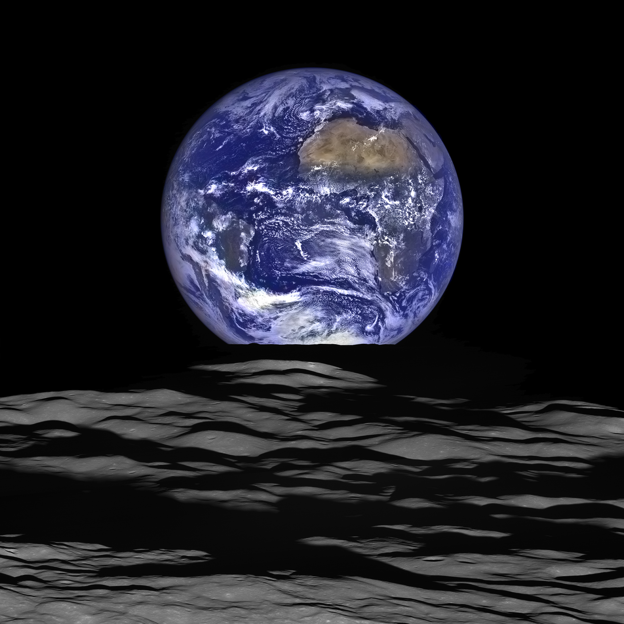
A full Earth straddles the edge of the moon, as seen from lunar orbit above Compton crater in the foreground. On Earth, Africa is visible at center right, and South America can be glimpsed through clouds at left. Photo by NASA/GSFC/Arizona State University
Question: This was no selfie. It was complicated. What are some of the pieces that had to come together to make this photo?
Answer: Just a few of the steps: You have to roll the spacecraft, in this case about 70 degrees, but the spacecraft is traveling at over 1,600 meters per second. We’re restricted in the length of one exposure time to something close to 0.4 milliseconds. You also move the spacecraft in the direction of flight so that you can get a wide enough field of view. When a spacecraft is in an elliptical orbit, the timing changes from image-to-image in an orbit. We have to compute all of that beforehand to get it exactly right. … That timing has to be precisely carried out. … We have to predict the temperature of the CCD (electronic equivalent of film). The Wide Angle Camera (WAC) is imaging an area multiple times while the Narrow Angle Cameras (NAC) takes just one picture. We blow up the WAC images and combine them to produce higher resolution, and then overlay this sharper image on the NAC image. We wanted the Earth to be on the horizon, and that only happens from certain areas of the moon. It’s only when the spacecraft is above the boundary between the nearside and farside that you can see the Earth behind the limb (edge of the moon).
Q: How did you know this image would be possible?
A: We’ve taken pictures of the Earth more than 10 times in the past. We wanted to get a limb shot (showing the edge of the moon). What makes it really hard is getting the moon in the foreground. … That was not by accident. We have software tools that allow us to visualize observations. We know where the spacecraft is going to be in the future. … We determined from which orbits the Earth will be visible near the limb. Once we know the ground track where the Earth will be visible, we then find a view with a dramatic foreground.
Q: LRO has been in orbit for more than six years. If you picked the best shots to show your friends, what are they?
A: We’ve taken more than a million images. My answer changes every three days. The Apollo landing sites are fantastic. You can see the tracks the astronauts left on the surface of the moon. To me, as a scientist, it’s really great because it helps me visualize the photographs they took on the surface. The significance of the geologic context. ‘All right, now I know they got that soil sample there, and I can see what it looks like.’
See a sampling of images (and explanations) from the LROC website below; Q&A continues below the gallery.
Q: What are the most interesting maneuvers and shots you plan with the cameras for the coming year?
-

The most common questions to the LROC team before launch concerned what they would see at the Apollo sites. The orbiter's Narrow Angle Camera shows a number of items, such as the still-standing flag from Apollo 17. Mark Robinson wrote he was a bit surprised the flags survived the harsh ultraviolet light and temperatures of the lunar surface.
Photo by NASA/GSFC/Arizona State University
-

Do not adjust your TV sets: This is a 3-D anaglyph of a mosaic of the lunar nearside taken at low-Sun conditions. 3-D stereo glasses are needed to see it in its full glory. If you don't have your own red/blue 3-D glasses, find instructions on how to make some here.
Photo by NASA/GSFC/Arizona State University
-

Bright talus winds downslope through crags and crannies in the banded scarps exposed in the east wall of Dionysius crater. Read more about the image and what causes the striations here.
Photo by NASA/GSFC/Arizona State University
-

This two-planet perspective was acquired in a single NAC image pair as the Lunar Reconnaissance Orbiter pitched to face the Earth on May 24, 2014. Mars is about 12 pixels wide; Earth was downscaled by a factor of eight to create this composite image. Read more here on how it was done.
Photo by NASA/GSFC/Arizona State University
-

LRO was moved into a lower orbit to capture this image of the Apollo 17 landing site. Paths of walking astronauts (single line) and lunar buggy tracks (double) are visible. Click to the next photo to see a labeled version.
Photo by NASA/GSFC/Arizona State University
-

The labeled landing site of the 1972 Apollo 17, the final mission of NASA's Apollo program.
Photo by NASA/GSFC/Arizona State University
-

One of many newly discovered young volcanic deposits — this example is near the crater Maskelyne. The direction of sunlight is from the right, and north is up. Read more about evidence for young lunar volcanism here.
Photo by NASA/GSFC/Arizona State University
-

LROC has captured many sensational views of the crater Giordano Bruno, returning again and again because it is a nearly pristine example of the effects of impacts on the lunar surface. It displays an immense ejecta blanket; read more here.
Photo by NASA/GSFC/Arizona State University
-

The lack of lunar atmosphere (and thus, wind and rain) can have its benefits: less erosion on landforms. Moon erosion is due to to impacts and gravity. In the case of lovely Lichtenberg B, gravity has not yet made the crater smooth, and there are few impacts nearby.
Photo by NASA/GSFC/Arizona State University
-

The orbiter turned to image the Earth four times during the solar eclipse on May 20-21, 2012; in this view, the moon's shadow is seen passing over the Aleutian Islands. Read more here.
Photo by NASA/GSFC/Arizona State University
-

The LROC photographed the Apollo 11 landing site, as Armstrong and Aldrin left it some 45 years ago. Find more, including photos from that mission, here.
Photo by NASA/GSFC/Arizona State University
-

Tycho crater, photographed at sunrise, is a very popular target with amateur astronomers. The central peak rises more than 6,562 feet above the crater floor, and the far wall exhibits more than 14,764 feet of relief. See a dramatic closeup of this image and read more here.
Photo by NASA/GSFC/Arizona State University
-

This image highlights contrasting features of young (lower right) and old (upper left) craters with almost the same diameters (about 1,500 feet). These two craters are found in the western portion of Mare Frigoris. Read more here.
Photo by NASA/GSFC/Arizona State University
-

LRO experiences twelve Earthrises every day; however, LROC is almost always busy imaging the lunar surface. On Feb. 1, 2014, LRO pitched forward while approaching the north pole, allowing the Wide Angle Camera to capture the Earth rising above Rozhdestvenskiy crater.
Photo by NASA/GSFC/Arizona State University
-

Central mounds, each with a diameter of about 3,280 feet, on the floor of Harriot B crater. They are likely weathered central peaks, formed by the gravitational collapse of the crater walls, which pushes material into the center of the crater, and from the rebound of the floor. Read more here.
Photo by NASA/GSFC/Arizona State University
-

When space life imitates art: This mosaic image shows a small portion of the ejecta blanket of an unnamed fresh impact crater on the southeastern wall of crater Darwin C. Read more here.
Photo by NASA/GSFC/Arizona State University
A: We’re writing a proposal to get funding to extend the mission — right now we are scheduled to be turned off on Sept. 15. One of the fantastic things we’re doing with the cameras now … we would like to get temporal coverage (photos of the same area months or years apart). We compare the before image and the after image. In 70 percent of them, we find small changes to the surface; almost all are due to impacts. We have discovered 222 new craters that have formed since we’ve been in orbit (2009). The pace of discovery is going to accelerate. One thing we want to nail down is the current impact rate.
Q: What is the most important thing you, and scientists generally, have learned from the LRO?
A: That the moon is a dynamic place. There is this paradigm that grew up with the moon as this dead place, kind of shut off, nothing happening on it anymore except impacts. We’ve discovered there are very young volcanic deposits, maybe even eruptions in the future. Conventional wisdom was that all lunar volcanism shut off between 1 billion and 2 billion years ago. That’s a big change in how we think about the moon. … There’s a lot more heat in the moon than we thought. … We have discovered thousands of small fault scarps — some even deform very small craters (10 meters). Small craters erode away quickly due to other small impacts. Since the faults deform these craters, the faults must have formed recently. Since there are thousands of these faults randomly distributed around the moon, that’s proof that the lunar core is still cooling and transitioning from liquid to solid. The moon is shrinking.
An exhibit that includes images from the ASU cameras, 3-D models of the lunar surface and an interactive kiosk is scheduled to open in February at the National Air & Space Museum in Washington, D.C.